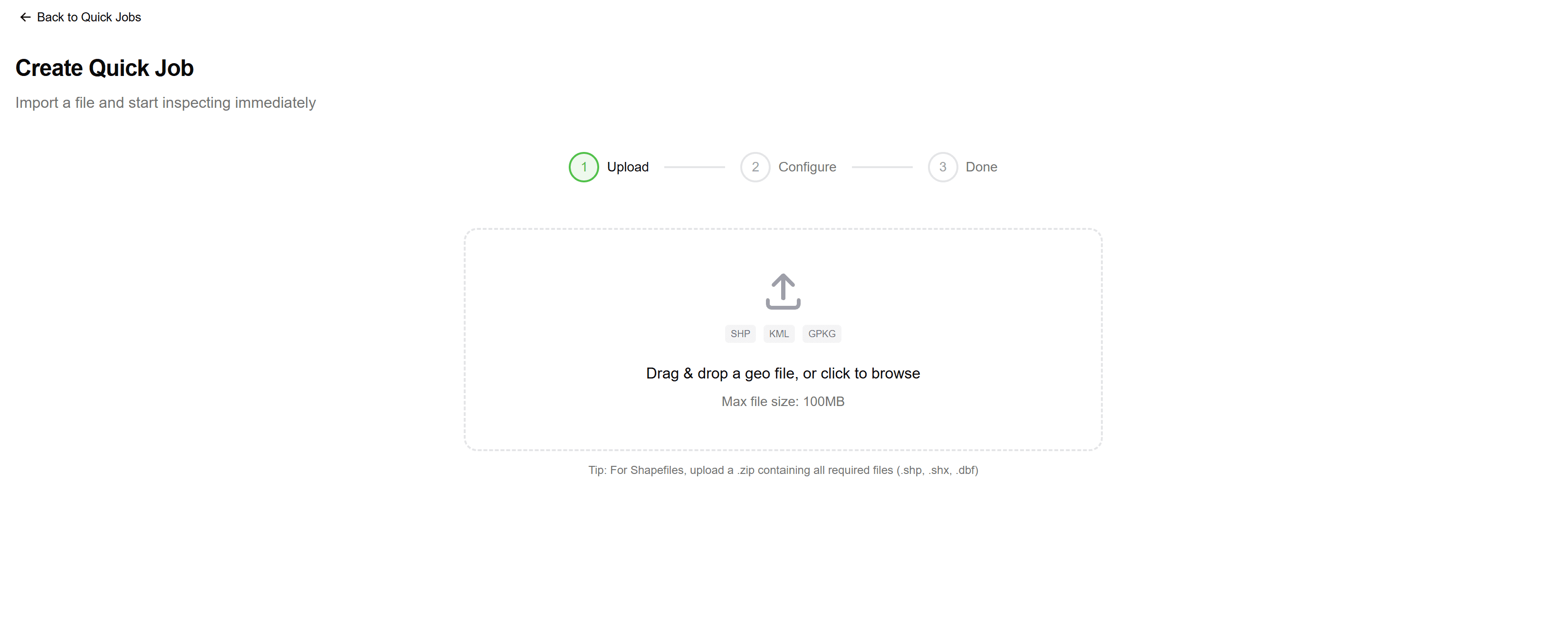
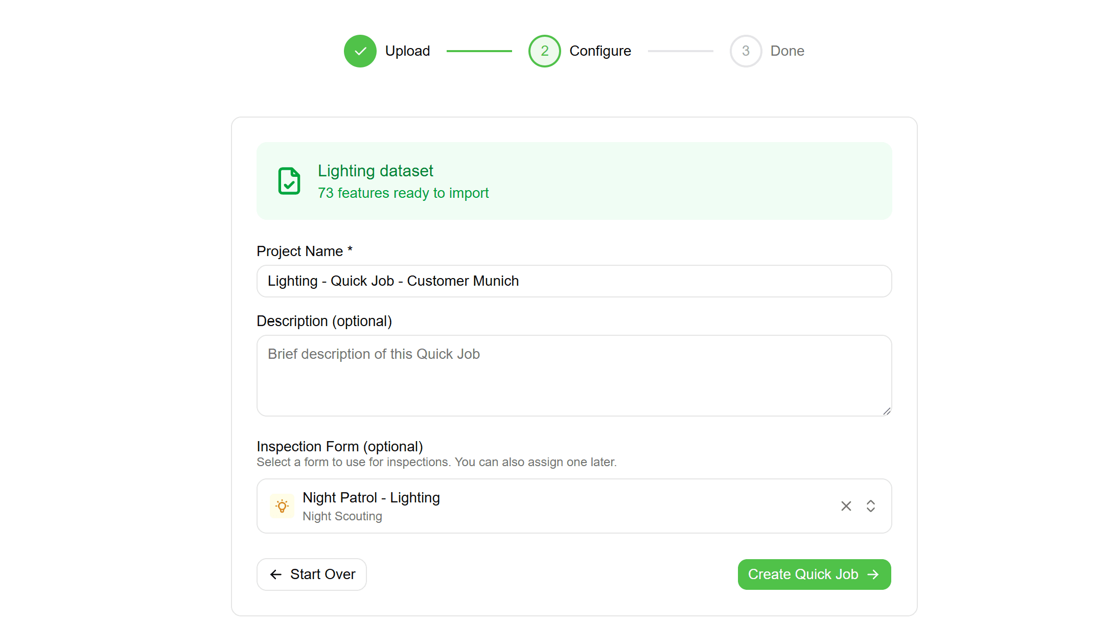
Features

Everything you need.
Nothing you don't.

Built for contractors and consultants who need professional tools without the enterprise complexity.

See everything on the map

Points, lines, polygons—all your client's assets visualized instantly. No more imagining where things are from spreadsheet coordinates.

GPS + visual placement for maximum accuracy
Capture data 3x faster than traditional methods
See your work on the map in real-time
Forms attach directly to map features
See everything on the map

Built for multi-client work

Switch between clients instantly. Keep projects, forms, and data completely separate. Deliver to each client in their preferred format.

Complete data separation between clients
Different forms and workflows per client
Deliver in each client's preferred format
Add new clients without complexity
Built for multi-client work

Forms that match your workflow

Drag-and-drop form builder. Text, numbers, dropdowns, photos—create exactly what your inspections need. Use across all projects.

Match your exact inspection requirements
Conditional logic shows relevant fields only
Same form for every team member
Required fields prevent incomplete data
Forms that match your workflow

Speak every format

GeoJSON, Shapefile, DXF, CSV, KML—bring data from any source. Take over client datasets without conversion headaches.

All major GIS formats supported
Existing asset IDs and attributes preserved
Automatic coordinate system detection
Visual attribute-to-field mapping
Speak every format

Know where every job stands

See completion status across all features in a project. Track your team's progress in real-time. No more "did we finish that site?"

Real-time team locations and progress
Clear geographic area assignments
Prevent overlapping or missed work
Instant notifications on completions
Know where every job stands

Quick Jobs for ad-hoc work

Upload a Shapefile or DXF, get an inspection-ready project in minutes. Perfect for one-off jobs without the setup overhead.

Go from file upload to field work in under 5 minutes
Import Shapefiles, GeoJSON, KML, DXF, and DWG files directly
No organisation or layer configuration required
Projects auto-archive after 90 days
Quick Jobs for ad-hoc work

Convert any geo format

Shapefile, GeoJSON, KML, DXF, DWG—convert between formats instantly. CAD support sets us apart from other GIS tools.

Support for Shapefile, GeoJSON, KML, GeoPackage, DXF, and DWG
CAD file support is rare in web-based GIS tools
Automatic coordinate reference system detection and transformation
Attribute data preserved with correct data types
Convert any geo format

Structured field inspections

Required fields, photo validation, and real-time error checking. Ensure complete, consistent data from every field visit.

Real-time validation catches errors immediately
Required fields ensure complete data collection
Photo requirements guarantee visual documentation
Every inspection links to the exact map feature
Structured field inspections

Find exactly what you need

Query by attributes, date ranges, and status. Build complex filters visually. Save and share filtered views via URL.

Visual query builder—no SQL or technical knowledge required
Filter by any attribute field and value
Date range filters for inspection history
Filter by inspection status: pending, in progress, completed, skipped
Find exactly what you need

Track changes over time

Every inspection adds to the record. See how conditions change, compare photos across years, build the full asset story.

Complete history of all inspections for every feature
Track how any attribute changes over time
Visual timeline of inspection events
Compare current state against previous inspections
Track changes over time

Organise work into projects

Group features, assign teams, set deadlines. Watch progress bars fill. Know exactly what's done and what's left.

Group features into logical work packages
Assign projects to specific team members
Set expected start and end dates
Real-time progress tracking and completion percentages
Organise work into projects

Ready to get your field data on the map?

Stop fighting your tools. Get the field data platform built for how you actually work.

Sign Up Free →
No credit card required·Free trial included