Quick Jobs
From file upload to field-ready inspection project in under 5 minutes
Sometimes you need to inspect assets without the overhead of creating organisations, setting up layers, and configuring complex workflows. Quick Jobs is designed for ad-hoc work—upload a Shapefile, GeoJSON, or DXF file, and Geocadra instantly creates an inspection-ready project. Perfect for one-off contractor jobs, emergency assessments, or pilot projects before committing to a full implementation. No setup friction, no wasted time, just immediate productivity.
The Overhead of Traditional GIS Project Setup
Traditional GIS workflows require significant setup before any field work can begin. You need to create a database, define schemas, import data, configure symbology, set up forms, assign permissions, and deploy to field devices. For a quick inspection job—say, assessing 50 trees after a storm or surveying a potential project site—this overhead can take longer than the actual field work. Many teams resort to paper forms or disconnected apps, losing the benefits of proper spatial data management just to avoid the setup burden.
How Geocadra Solves This
Quick Jobs eliminates setup friction entirely. Upload your data file—Shapefile, GeoJSON, KML, DXF, or DWG—and Geocadra automatically creates everything you need: a project workspace, imported features on the map, and associated inspection forms. Within minutes, your team can start inspecting in the field. When the job is complete, export your results and archive the project. Quick Jobs auto-expire after 90 days, keeping your workspace clean without manual housekeeping.
Go from file upload to field work in under 5 minutes
Import Shapefiles, GeoJSON, KML, DXF, and DWG files directly
No organisation or layer configuration required
Projects auto-archive after 90 days
Same powerful inspection tools as standard projects
Export results in any format when complete

How It Works
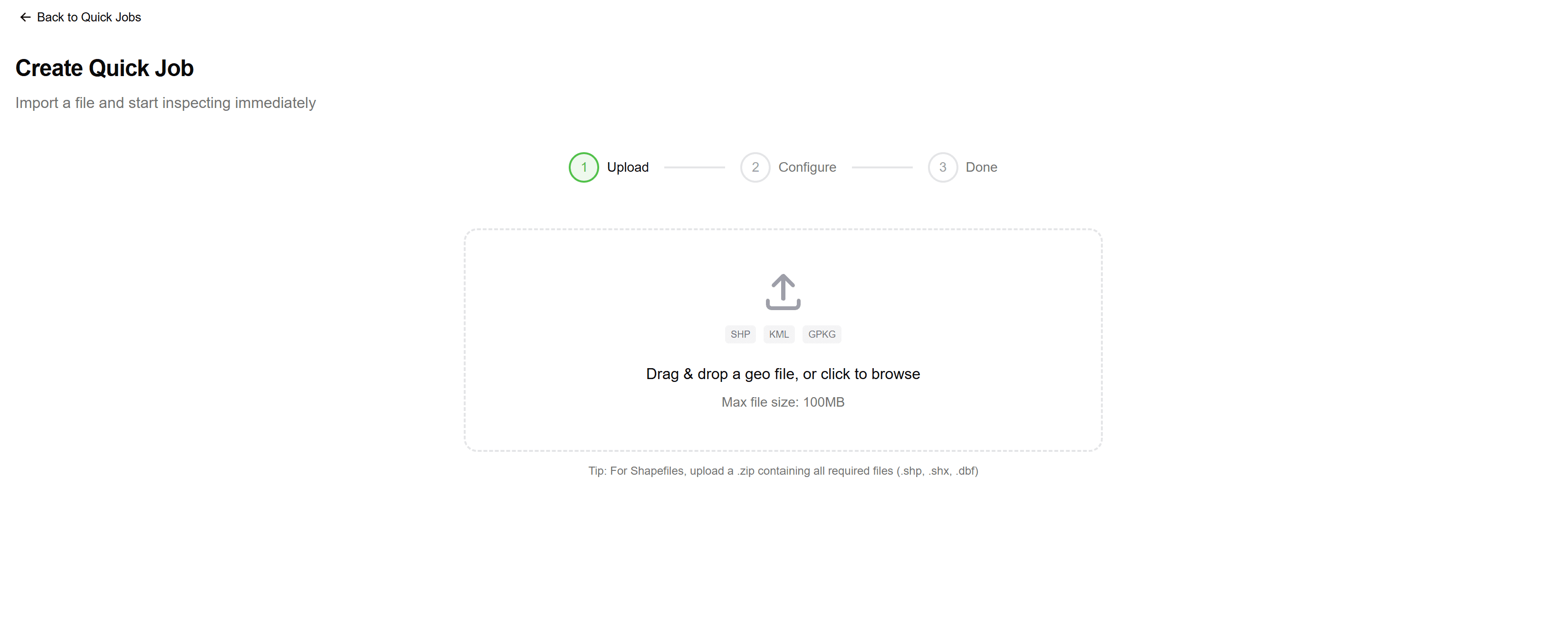
Upload Your Data File
Drag and drop your geospatial file into the Quick Jobs wizard. Geocadra supports Shapefiles (as ZIP), GeoJSON, KML, GeoPackage, DXF, and DWG files. The system automatically detects the file format and coordinate reference system.

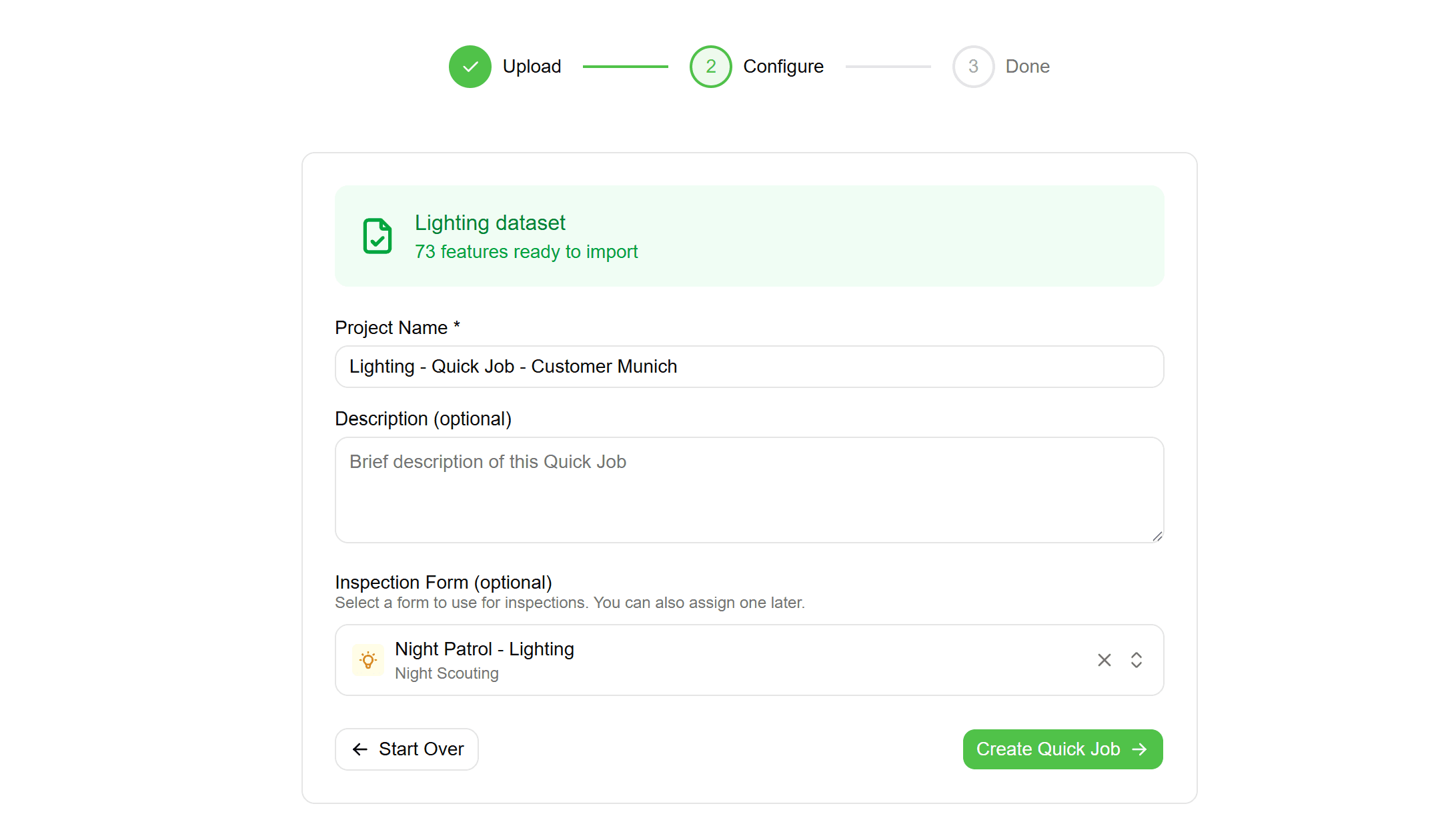
Preview and Configure
See a preview of your data—layer structure, feature count, geometry type, and attribute fields. Give your project a name and description. Optionally select an inspection form to attach, or use the default quick inspection form.
Create Project Instantly
Click create and Geocadra builds everything automatically—a hidden organisation for quick jobs, a layer with your imported features, and a project ready for inspection. The entire process takes seconds, even for files with hundreds of features.

Inspect in the Field
Open the Quick Jobs list on any device and start inspecting immediately. Features appear on the map exactly as imported. Tap any feature to open the inspection form, record observations, take photos, and mark completion status.
Export and Archive
When the job is complete, export your inspection data in any supported format—Shapefile, GeoJSON, Excel, or PDF report. Mark the project as complete and it will auto-archive after 90 days, or archive immediately to clean up your workspace.
Common Use Cases
Emergency Assessments
After storms, floods, or other events, quickly assess damage across affected assets. Upload your asset register, deploy teams immediately, and have structured inspection data within hours instead of days.
One-Off Contractor Jobs
When a client sends you a Shapefile of assets to inspect, don't waste time setting up permanent infrastructure. Create a Quick Job, complete the inspection, deliver results, and archive—all without cluttering your main workspace.
Pilot Projects
Test Geocadra with real data before committing to a full implementation. Upload a sample dataset, run through the inspection workflow, and evaluate the results without any long-term setup investment.
Rapid Field Surveys
For site assessments, feasibility studies, or preliminary surveys, Quick Jobs gets you collecting structured spatial data immediately. Convert CAD drawings to inspectable features without GIS expertise.
Frequently Asked Questions
How many Quick Jobs can I have active?
The number of active Quick Jobs depends on your plan tier—Starter allows 5 active Quick Jobs, Professional allows 20, and Business/Enterprise plans have unlimited active Quick Jobs. Completed and archived jobs don't count against this limit.
What happens when a Quick Job expires?
Quick Jobs auto-archive 90 days after being marked complete. Archived jobs remain accessible in read-only mode and can be exported, but no new inspections can be added. You can also manually archive jobs at any time.
Can I convert a Quick Job to a permanent project?
Yes, if a Quick Job grows into ongoing work, you can convert it to a standard project within a proper organisation. Your data, inspection history, and team assignments transfer over seamlessly.
How does DXF/DWG import work?
Geocadra converts CAD files to GIS features using our integrated GeoConverter. Layers from the CAD file become separate feature sets. You can preview the conversion results before creating the project to ensure the data imported correctly.
Explore More Features

See everything on the map
Points, lines, polygons—all your client's assets visualized instantly. No more imagining where things are from spreadsheet coordinates.

Built for multi-client work
Switch between clients instantly. Keep projects, forms, and data completely separate. Deliver to each client in their preferred format.

Forms that match your workflow
Drag-and-drop form builder. Text, numbers, dropdowns, photos—create exactly what your inspections need. Use across all projects.