Field Inspections
Structured data collection workflows that ensure complete, accurate asset assessments
Field inspection is at the heart of asset management—but traditional approaches leave too much to chance. Paper forms get lost, digital notes lack structure, and photos end up disconnected from the assets they document. Geocadra's inspection workflow brings structure to field work: every feature gets a standardised assessment, every observation links to the exact location, and every photo attaches to the correct record. The result is consistent, auditable data that actually supports decision-making.

The Challenge of Consistent Field Data
Field teams are under pressure to cover ground quickly, and data quality often suffers. Inspectors skip fields they consider unimportant, use inconsistent terminology, forget to take required photos, or record observations against the wrong assets. Without real-time validation, these errors aren't caught until the data reaches the office—at which point fixing them requires expensive field revisits. The result is inspection databases full of gaps, inconsistencies, and unreliable information that can't support maintenance planning or regulatory compliance.
How Geocadra Solves This
Geocadra enforces data quality at the point of collection. Required fields can't be skipped. Photo minimums ensure visual documentation. Feature selection from the map eliminates wrong-asset errors. Real-time validation catches out-of-range values immediately. When an inspection is complete, you know it's complete—no gaps, no guesses, no revisits needed. Batch inspection capabilities let you process multiple features efficiently, while status tracking shows exactly what's been done and what remains.
Real-time validation catches errors immediately
Required fields ensure complete data collection
Photo requirements guarantee visual documentation
Every inspection links to the exact map feature
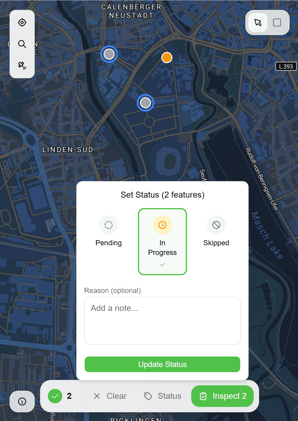
Status tracking shows pending, in-progress, and completed work
Batch capabilities for efficient multi-feature inspections
How It Works
Select Features to Inspect
Navigate the map to find features requiring inspection. Features display their current status—pending, in progress, or completed. Tap a feature to open its inspection form, or use the feature list for sequential processing.
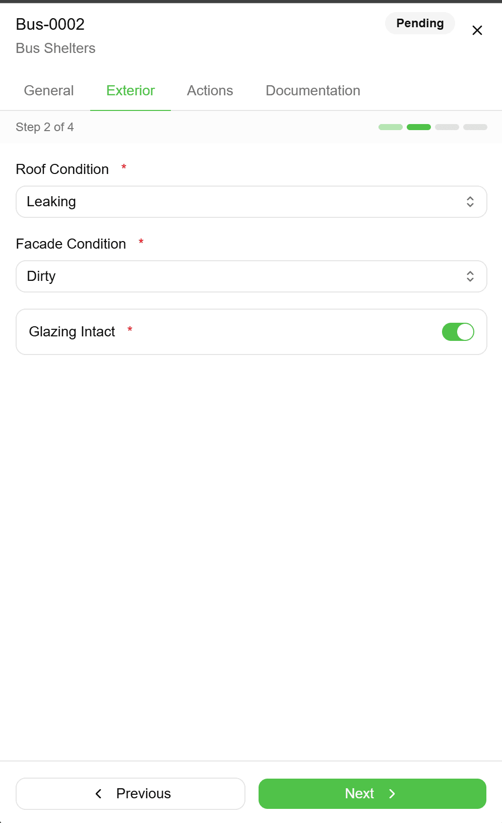
Complete the Inspection Form
Work through the form fields—condition ratings, measurements, observations, defect categories, and any custom fields defined for this inspection type. Required fields must be completed before you can proceed.
Capture Photo Evidence
When you reach photo fields, the camera opens automatically. Capture the required images—overview shots, detail photos, nameplate captures, or defect documentation. Each photo is geotagged and timestamped automatically.
Submit and Update Status
Review your entries and submit the inspection. The feature's status updates automatically—from pending to completed, or to a custom status based on your findings. Timestamps and inspector attribution are recorded for the audit trail.
Move to Next Feature
After submission, navigate to the next feature needing inspection. The map and feature list show remaining pending items. Continue until all assigned features are complete, with progress tracked in real-time.
Common Use Cases
Asset Condition Assessments
Systematic evaluation of asset health using standardised rating scales. Condition scores, defect types, and severity ratings feed directly into maintenance planning systems.
Regulatory Compliance Inspections
Meet regulatory requirements with documented, timestamped inspections. Required fields ensure nothing is missed. Photo evidence proves compliance. Digital signatures capture inspector certification.
Asset Inventory Verification
Ground-truth existing asset databases by visiting each feature and confirming or updating recorded attributes. Flag missing assets, document new installations, and correct location errors.
Post-Maintenance Verification
After maintenance work is performed, verify completion and document the result. Before/after photos provide evidence of work completed. Updated condition ratings reflect improvements.
Frequently Asked Questions
Do inspections work offline?
Yes, inspections work fully offline. Complete forms, capture photos, and update statuses without network connectivity. Data syncs automatically when you're back online—you won't lose any work.
Can I inspect the same feature multiple times?
Yes, features can be inspected repeatedly to track condition over time. Each inspection is timestamped and preserved in the feature's history. You can compare current observations against past inspections.
Can I save partial inspections?
Yes, you can save work in progress and return later. The feature shows as 'in progress' until you submit the final inspection. This is useful for complex assessments that can't be completed in one visit.
How are features assigned to inspectors?
Features can be assigned to specific team members, or left available for anyone on the project. Managers can assign work areas geographically, ensuring clear ownership and preventing duplicate inspections.
Explore More Features
See everything on the map
Points, lines, polygons—all your client's assets visualized instantly. No more imagining where things are from spreadsheet coordinates.

Built for multi-client work
Switch between clients instantly. Keep projects, forms, and data completely separate. Deliver to each client in their preferred format.

Forms that match your workflow
Drag-and-drop form builder. Text, numbers, dropdowns, photos—create exactly what your inspections need. Use across all projects.