The German federal standard for systematic biotope mapping, classification, and ecological valuation under the BKompV.
The BfN Biotope Survey (Biotoptypenkartierung) is Germany's authoritative methodology for identifying, classifying, and valuing biotopes in the context of environmental impact compensation. Published by the Bundesamt fuer Naturschutz (BfN) in BfN-Schriften 721, this standard provides the field mapping instructions for Anlage 2 of the Bundeskompensationsverordnung (BKompV). It enables consistent biotope assessment across all German federal infrastructure projects, translating ecological observations into a standardized point-based valuation system that drives legally binding compensation calculations.
What is BfN Biotope Survey?
The BfN Biotope Survey (Biotoptypenkartierung) is the German federal standard for mapping and valuing biotopes under the Bundeskompensationsverordnung (BKompV). Surveyors classify biotope types from a catalog of approximately 668 entries and assign a Biotopwert from 0 to 24 points to calculate nature-impact compensation.
- Full Name
- Kartieranleitung fuer die Biotoptypen nach Anlage 2 der Bundeskompensationsverordnung (BfN-Schriften 721)
- Issuing Body
- BfN (Bundesamt fuer Naturschutz / Federal Agency for Nature Conservation)
- Current Revision
- BfN-Schriften 721 (2025)
The BfN Biotope Type Classification System (Anlage 2 BKompV)
The classification system assigns every biotope a hierarchical numeric code from a standardized catalog of approximately 668 types, forming the basis for all subsequent valuation.
The core of the BfN Biotope Survey is the biotope type classification defined in Anlage 2 of the Bundeskompensationsverordnung (BKompV). This classification catalog contains approximately 668 distinct biotope types organized in a hierarchical numeric code system. Each code consists of two to four numeric segments separated by dots, with optional letter suffixes for subtypes. For example, code 34.02a designates "Halbtrockenrasen auf karbonatischem Untergrund" (semi-dry grassland on calcareous substrate), while 41.01 identifies "Hainsimsen-Buchenwald" (woodrush beech forest). The hierarchical structure groups related biotopes under shared major categories: codes beginning with 02 cover marine and coastal biotopes, 33 through 37 address open land habitats from heathlands to tall-sedge marshes, 41 through 44 represent forest types, and codes above 50 classify anthropogenic or urban biotope types.
Each biotope patch is further categorized as a Hauptbiotop (main biotope), Begleitbiotop (secondary biotope), or Komplexflaeche (complex area). A Hauptbiotop is the dominant habitat type occupying the largest proportion of the mapped unit. A Begleitbiotop is a subordinate habitat type that co-occurs within the same spatial unit but covers a smaller share. Komplexflaeche designations apply when two or more biotope types are so finely interspersed that they cannot be meaningfully separated at the mapping scale. This distinction matters because the valuation calculation uses the area proportion of each biotope type as a multiplier.
| Code | Biotope Type (German) | English Translation | Base Value (WP) |
|---|---|---|---|
| 02.01.01.01 | Felsen-/Steingrund mit Epibenthos | Rock/stone substrate with epibenthic communities | 17 |
| 33.01 | Zwergstrauchheiden | Dwarf shrub heathlands | 15–21 |
| 34.02a | Halbtrockenrasen (Kalk) | Semi-dry grassland (calcareous) | 21 |
| 35.01a | Kalkreiches Niedermoor | Calcareous fen | 24 |
| 37.01 | Grossseggenried | Tall-sedge marsh | 20 |
| 41.01 | Hainsimsen-Buchenwald | Woodrush beech forest | 18 |
| 51.11a | Sport/Spiel/Erholung (versiegelt) | Sports/recreation area (sealed) | 0 |
The full Anlage 2 BKompV catalog contains approximately 668 biotope types. Base values (Grundwert) range from 0 for fully sealed anthropogenic surfaces to 24 for the most ecologically valuable natural habitats.
The surveyor must also record any applicable legal protection status. German law provides three overlapping layers of biotope protection: Section 30 BNatSchG (Federal Nature Conservation Act) protects specific habitat types nationwide, FFH-Lebensraumtyp (Fauna-Flora-Habitat Directive habitat type) designations apply under EU law for sites within the Natura 2000 network, and individual Landesrecht (state law) provisions may add further protection categories. In the digital form, the Gesetzlicher Schutz (Legal Protection) field accepts multiple simultaneous selections because a single biotope can fall under all three protection categories at once.
For a comparable British habitat classification methodology, see the JNCC Phase 1 Habitat Survey standard.
The 0-to-24 Biotopwert Scoring System (BKompV Section 5)
The Biotopwert (biotope value) is the primary quantitative output of the BfN survey, expressed as a point score from 0 to 24 that drives legally mandated compensation calculations.
The Bundeskompensationsverordnung (BKompV) Section 5 defines a point-based valuation system where every biotope type receives a Grundwert (base value) between 0 and 24 Wertpunkte (value points). This base value reflects the intrinsic ecological significance of the biotope type under undisturbed, typical conditions. A fully sealed sports facility (code 51.11a) carries a Grundwert of 0 points because it provides essentially no ecological function. At the opposite end, a calcareous fen (code 35.01a) receives the maximum Grundwert of 24 points, reflecting its exceptional biodiversity, rarity, and irreplaceability. The base value is predetermined by the classification code selected during the survey and is not subject to field interpretation.
| Points (Biotopwert) | Wertstufe | English Translation | Compensation Significance |
|---|---|---|---|
| 0–4 | Sehr gering | Very Low | Minimal compensation required |
| 5–9 | Gering | Low | Basic compensation measures |
| 10–15 | Mittel | Medium | Standard compensation ratios apply |
| 16–18 | Hoch | High | Enhanced compensation or offset measures |
| 19–21 | Sehr hoch | Very High | Significant compensation area required |
| 22–24 | Hervorragend | Outstanding | Highest compensation, avoidance preferred |
Wertstufen are defined in BKompV Section 5 Paragraph 2. The total Biotopwert equals Grundwert plus the adjustment (Auf-/Abwertung), clamped between 0 and 24.
The final Gesamt-Biotopwert (total biotope value) is calculated as Grundwert plus Auf-/Abwertung (adjustment), clamped to the range of 0 to 24. This score is then mapped to one of six Wertstufen (value levels) defined in BKompV Section 5 Paragraph 2. The Wertstufe determines the compensation multiplier applied when an infrastructure project impacts the biotope. Destroying a biotope with a "hervorragend" (outstanding) Wertstufe requires substantially more compensation area or ecological offset measures than impacting a "gering" (low) value biotope. This direct link between field survey scores and legal compensation requirements makes accurate classification and valuation critical.
Auf-/Abwertung: Adjusting the Biotope Value by Up to 3 Points
BKompV Section 5 allows surveyors to adjust the base value by -3 to +3 points based on the actual condition of the specific biotope occurrence relative to its typical form.
The Auf-/Abwertung (value adjustment) mechanism is the key field decision in the BfN Biotope Survey. While the Grundwert is fixed by the classification code, the adjustment reflects the on-site ecological quality of the specific biotope occurrence compared to the typical expression of that type. BKompV Section 5 Paragraph 1 permits adjustments from -3 to +3 points in integer steps. A value of 0 means the biotope matches its expected typical condition. Positive adjustments (+1 to +3) indicate above-average quality, such as exceptionally large area, high species diversity, presence of rare structural features, or excellent connectivity to adjacent natural habitats. Negative adjustments (-1 to -3) indicate below-average quality, such as fragmentation, species poverty, degradation from eutrophication, or isolation from other natural areas.
The adjustment decision is supported by three assessment criteria defined in the standard: Flaeche (area), Ausstattung (equipment/features), and Lage (location/connectivity). The Flaeche criterion compares the patch size to what is typical for the biotope type. An unusually large contiguous area of semi-dry grassland would justify a positive area score, while a tiny remnant fragment would receive a negative score. The Ausstattung criterion evaluates the presence and quality of abiotic and biotic features such as deadwood (Totholz), cavity trees (Hohlenbaeume), water bodies (Gewaesser), and rock outcrops (Fels/Stein). A beech forest with abundant cavity trees and a rich understory deserves a higher Ausstattung score than a structurally impoverished monoculture stand. The Lage criterion assesses how well the biotope is connected to surrounding natural habitats and landscape corridors. A well-connected wetland embedded within a corridor of riparian habitats scores higher than an isolated patch surrounded by intensive agriculture.
| Adjustment | Direction | Meaning | Typical Justification |
|---|---|---|---|
| +3 | Aufwertung (Upgrade) | Exceptional quality | Outstanding area, species richness, and connectivity combined |
| +2 | Aufwertung (Upgrade) | Well above average | Two or more criteria clearly above average |
| +1 | Aufwertung (Upgrade) | Slightly above average | One criterion notably above average |
| 0 | Keine Aenderung | Typical condition | All criteria at expected level for this type |
| -1 | Abwertung (Downgrade) | Slightly below average | One criterion notably below average |
| -2 | Abwertung (Downgrade) | Well below average | Two or more criteria clearly below average |
| -3 | Abwertung (Downgrade) | Severely degraded | Strong deficits across all three criteria |
Adjustments are permitted under BKompV Section 5 Paragraph 1. A written justification (Begruendung) is required for any non-zero adjustment.
When the Auf-/Abwertung is anything other than 0, the surveyor must provide a written justification in the Begruendung field. This justification must reference the specific criteria that informed the adjustment. The requirement for documented reasoning ensures consistency between surveyors working on the same project and provides an audit trail for regulatory review. In legal proceedings, inadequately justified adjustments have been challenged and overturned, making thorough documentation essential for defensible impact assessments.
Try this BfN Biotope Survey form in Geocadra
We have a pre-built BfN Biotope Survey inspection template ready to go. Sign up and start your first condition assessment today.
Free 14-day trial. No credit card required.
Assessing Beeintraechtigungen (Impairments and Threats)
The impairment assessment documents active negative impacts affecting the biotope, providing critical context for both the value adjustment and compensation planning.
BKompV Section 5 Paragraph 3 requires the documentation of Beeintraechtigungen (impairments) that actively affect the biotope's ecological function. The BfN survey form captures five categories of impairment: Versiegelung (sealing/soil impermeabilization), Naehrstoffeintrag (nutrient input/eutrophication), Zerschneidung (fragmentation/habitat severance), Entwaesserung (drainage/dewatering), and Trittschaeden (trampling damage). Each impairment can occur independently or in combination. A wetland biotope adjacent to agricultural land might simultaneously suffer from nutrient input through runoff, drainage from adjacent ditches, and fragmentation by a road cutting through the habitat corridor.
| Impairment Type | German Term | Intensity Levels | Example |
|---|---|---|---|
| Soil Sealing | Versiegelung | Low / Medium / High | Partial paving at habitat edges |
| Nutrient Input | Naehrstoffeintrag | Low / Medium / High | Agricultural runoff causing eutrophication |
| Fragmentation | Zerschneidung | Low / Medium / High | Road or fence bisecting the habitat |
| Drainage | Entwaesserung | Low / Medium / High | Ditches lowering groundwater table in wetlands |
| Trampling Damage | Trittschaeden | Low / Medium / High | Recreational foot traffic compacting soil |
Impairment intensity follows BKompV Section 5 Paragraph 3. Multiple impairments can be recorded per biotope with independent intensity ratings.
Each recorded impairment receives an Intensitaet (intensity) classification of Gering (Low), Mittel (Medium), or Hoch (High). Low intensity indicates that the impairment is present but has not yet materially altered the species composition or ecological function of the biotope. Medium intensity means the impairment is actively degrading the habitat, with detectable changes in species composition or structural features. High intensity signals that the impairment has caused substantial ecological damage or is threatening the continued existence of the biotope type at this location. The intensity classification directly informs the value adjustment: a biotope with multiple high-intensity impairments would typically receive a negative Auf-/Abwertung, while a biotope that remains in excellent condition despite minor impairments may still warrant a positive adjustment.
Multiple impairments can be recorded for a single biotope since the impairment group in the form supports repeatable entries. This is important because ecological degradation is often the result of cumulative pressures rather than a single cause. An urban-fringe heathland might experience trampling damage from recreational use, nutrient input from adjacent road runoff, and fragmentation from surrounding development simultaneously. Recording each impairment separately ensures that the full pressure profile is documented for compensation planning and long-term monitoring.
For a related approach to ecological habitat assessment, see the JNCC Phase 1 Habitat Survey.
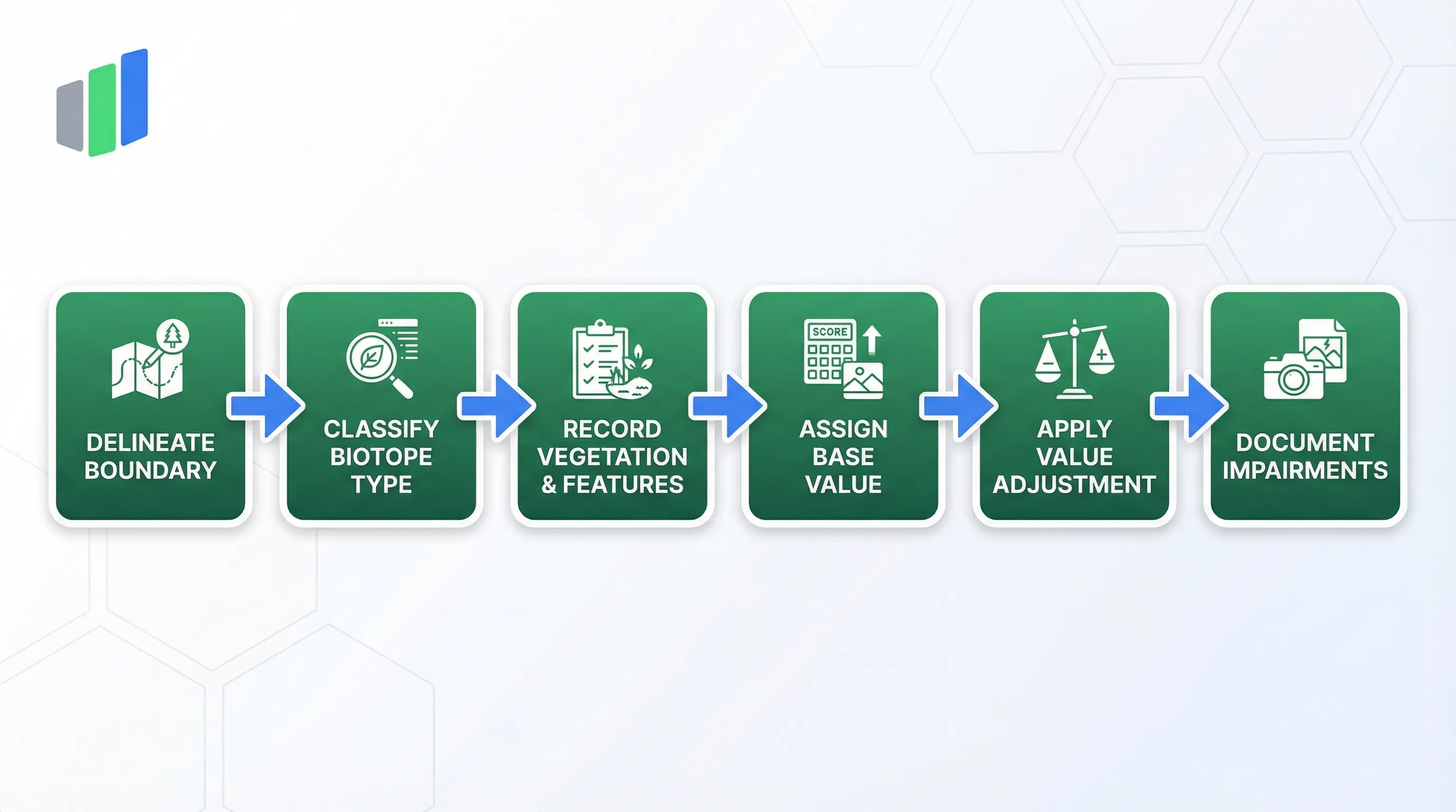
Field Survey Process: From Identification to Valuation
The BfN survey follows a structured six-step field workflow that translates ecological observations into legally binding point valuations.
The BfN Biotope Survey follows a defined field workflow. The surveyor begins by delineating the spatial boundary of the biotope patch, assigning a Flaechen-ID (area identifier) and recording the Geometrietyp (geometry type) as polygon, line, or point. Most biotope patches are mapped as polygons, but linear features like hedgerows or stream banks and point features like individual springs or geological outcrops are captured as lines or points respectively. The Kartierstatus (survey status) field distinguishes between a Neuerfassung (new survey) conducted for the first time, an Aktualisierung (update) that revisits a previously mapped biotope, and an Ueberprufung (verification check) that confirms whether the previous classification remains accurate.
After delineation, the surveyor assigns the biotope type code from the Anlage 2 BKompV catalog. This classification decision must be supported by documented evidence: the surveyor records the dominant plant species (Dominante Pflanzenarten) that characterize the habitat, the current land use or management regime (Nutzung/Pflege), and any notable structural features (Strukturmerkmale) such as deadwood, cavity trees, or water bodies. Photo documentation is mandatory, with at least one reference photograph required per biotope patch. These evidence fields collectively provide the justification for the selected classification code and support quality review by project coordinators.
The valuation phase assigns the Grundwert (base value) from the catalog, applies the Auf-/Abwertung (adjustment) based on the three quality criteria, and calculates the Gesamt-Biotopwert (total biotope value). The surveyor then documents any active Beeintraechtigungen (impairments) with their respective intensity levels. The completed survey record for each biotope patch thus contains the spatial reference, classification evidence, numerical valuation, and impairment documentation required for a complete BKompV-compliant impact assessment.
The current mapping instructions are published in BfN-Schriften 721, available through the Federal Agency for Nature Conservation.
The BKompV legislation is accessible via Gesetze im Internet.
Frequently Asked Questions
What is the BfN Biotope Survey?
The BfN Biotope Survey (Biotoptypenkartierung) is the German federal methodology for mapping and valuing biotopes under the Bundeskompensationsverordnung (BKompV). Surveyors classify biotopes from a standardized catalog of approximately 668 types and assign a value score from 0 to 24 points for environmental impact compensation calculations.
How is the Biotopwert (biotope value) calculated?
The Biotopwert is calculated by adding the Grundwert (base value, determined by the biotope type code from Anlage 2 BKompV) to the Auf-/Abwertung (adjustment from -3 to +3 points based on field quality). The result is clamped between 0 and 24 points and mapped to one of six Wertstufen (value levels).
What is the Auf-/Abwertung in the BfN Biotope Survey?
The Auf-/Abwertung is a value adjustment of -3 to +3 points applied to the base value. It reflects whether the specific biotope occurrence is above or below the typical condition for its type, based on three criteria: area (Flaeche), features/equipment (Ausstattung), and location/connectivity (Lage).
Is the BfN Biotope Survey mandatory in Germany?
The BfN Biotope Survey is mandatory for all federal infrastructure projects that require nature-impact compensation under the Bundeskompensationsverordnung (BKompV). State-level projects may follow similar methodologies defined under Landesrecht. The BKompV entered into force in 2020 and applies to interventions in nature and landscape.
What qualifications are needed to perform a BfN Biotope Survey?
Biotope surveyors must have specialized botanical and ecological knowledge to correctly identify plant communities and assign biotope type codes. In practice, surveys are conducted by trained ecologists, vegetation scientists, or environmental consultants with demonstrated competence in habitat classification and German nature conservation law.
What is the difference between Hauptbiotop and Begleitbiotop?
A Hauptbiotop (main biotope) is the dominant habitat type covering the largest area share within a mapped patch. A Begleitbiotop (secondary biotope) is a subordinate habitat type that co-occurs within the same spatial unit. Complex areas (Komplexflaeche) are designated when multiple types are too finely interspersed to separate.
How does the BfN Biotope Survey relate to the EU Habitats Directive?
Some BfN biotope types correspond to FFH-Lebensraumtypen (Fauna-Flora-Habitat Directive habitat types) protected under EU law. When a mapped biotope matches an FFH type, the surveyor records the FFH-LRT code alongside the BKompV code. FFH habitats typically receive high Grundwert scores and carry additional legal protection requirements.
Digitize your BfN Biotope Survey inspections
Replace paper forms and spreadsheets with structured digital inspections — built for standards like BfN Biotope Survey.
Free 14-day trial. No credit card required.