The UK standard for rapid, vehicle-based road condition surveys at network level.
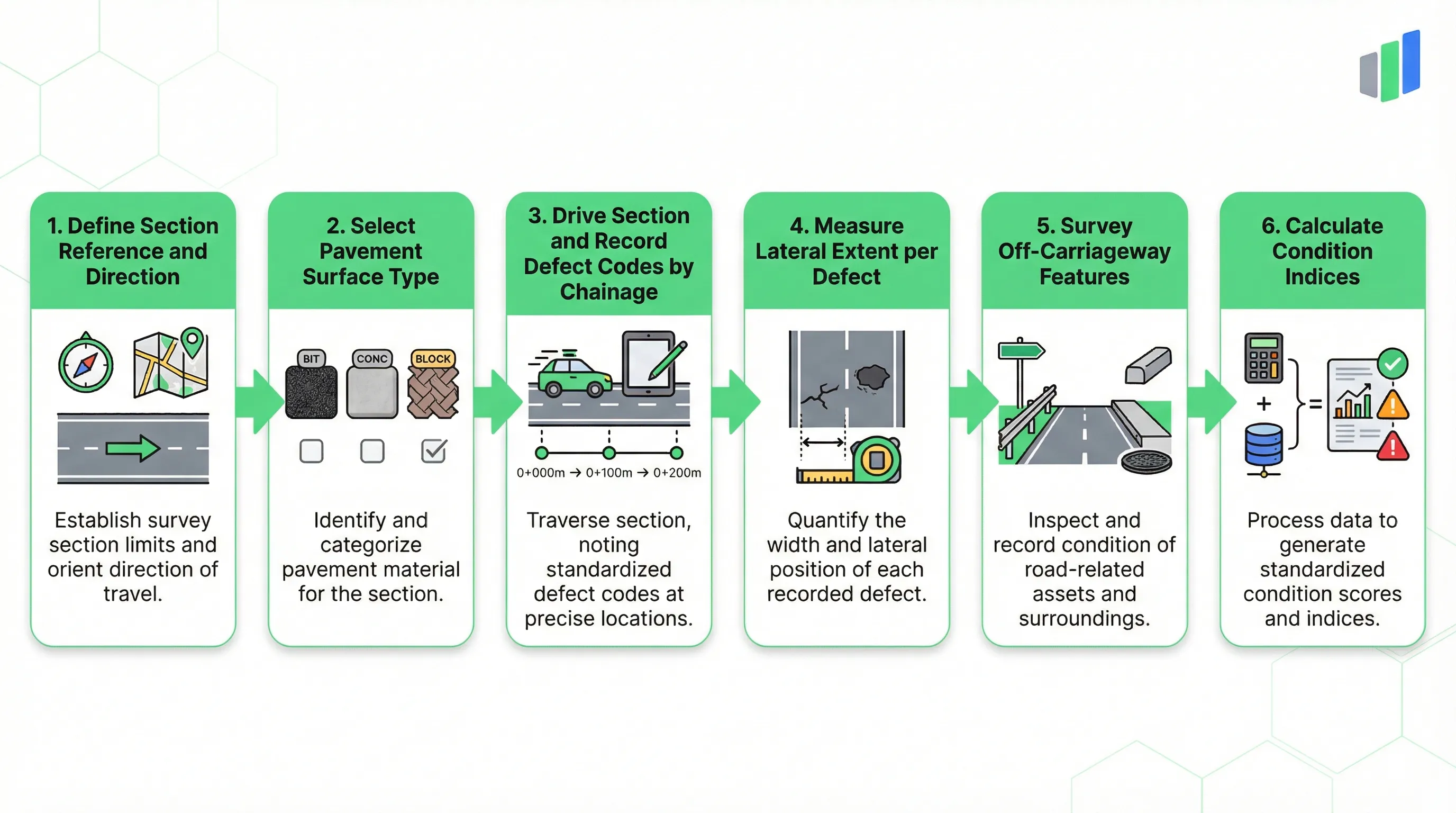
UKPMS CVI is the primary method for assessing road surface condition across the United Kingdom at network level. Conducted from a slow-moving vehicle at 10 to 40 kilometres per day, it captures a limited range of broadly defined defects along each road section. Each carriageway observation records the defect type code, start and end chainage, and a lateral extent or lane count that quantifies severity. Off-carriageway features such as footways and cycletracks are assessed separately using a Major/Minor severity classification. The collected data feeds into UKPMS-accredited systems that calculate Local, Partial, and General condition indices, supporting maintenance prioritisation and capital planning decisions across entire highway networks.
What is UKPMS CVI?
UKPMS CVI (Coarse Visual Inspection) is the United Kingdom standard for rapid, network-level road condition surveys conducted from a slow-moving vehicle. It records carriageway and footway defects by type, chainage, and lateral extent to generate condition indices for asset management and maintenance planning.
- Full Name
- Coarse Visual Inspection (UKPMS Volume 2, Chapter 7)
- Issuing Body
- UK Roads Liaison Group / Department for Transport
- Current Revision
- UKPMS Rules & Parameters v15
Section Header and Survey Parameters
Every CVI survey begins by defining the road section and its physical characteristics, which control the available defect codes and validation rules for all subsequent observations.
The Survey Setup header establishes the identity and context of the road section before the survey vehicle begins its pass. The Section Reference field links the survey to a specific network inventory record, typically formatted as a unique section ID such as U1234/01. This reference is the anchor that connects CVI observations to the asset management database and ensures that repeat surveys on the same section can be compared over time.
The Survey Direction field records whether the vehicle travels forward (with chainage) or in reverse (against chainage), which determines how distance measurements are calculated along the section. Start Chainage and Section Length in metres define the linear extent of the survey and provide the maximum bounds for defect chainage validation. Any observation entry with an end chainage exceeding the section length will be flagged as invalid.
The XSP Referencing Method controls how cross-sectional positions are recorded. Under the Minimal (Standard) method, the entire carriageway is treated as a single position designated "C". Under the Full method, individual lanes are identified as CL1, CL2 (left lanes) and CR1, CR2 (right lanes), enabling lane-specific defect mapping. The Pavement Surface Type field is the most consequential setup parameter: selecting Bituminous, Concrete, Block, or Mixed directly filters the defect type dropdown in the Carriageway Observations section. A bituminous surface exposes defect codes such as BCKJ (Wheel Track Cracking) and BWTR (Rutting), while a concrete surface exposes codes such as NCRA (Concrete Cracking) and NFLT (Transverse Joint Defect). This surface-dependent filtering prevents inspectors from recording defects that are physically impossible for the surface material present, which is a critical data quality safeguard for rapid, vehicle-based surveys where correction opportunities are limited.
Carriageway Defect Types by Surface Material
CVI uses a compact set of four-character defect codes where the first letter indicates the surface material category and the remaining characters identify the specific defect.
UKPMS CVI deliberately limits the number of defect types to enable rapid assessment from a moving vehicle. Unlike the Detailed Visual Inspection (DVI), which measures precise defect dimensions and employs a larger code catalogue, CVI captures only broadly defined defects that can be reliably identified at driving speed. Each defect code follows a consistent four-character pattern: the prefix letter indicates the surface category (B for Bituminous, N for Concrete, K for Block), and the remaining three characters identify the specific defect condition.
For bituminous carriageways, the eight core defect codes cover the full range of deterioration patterns. BCKJ (Wheel Track Cracking) targets fatigue cracking in the wheel paths, a primary indicator of structural failure in flexible pavements. BFEJ (Wearing Course Deterioration) captures loss of surface material including fretting, ravelling, and aggregate loss. BSDE (Surface Deterioration) records broader surface breakdown that extends beyond the wearing course. BSES (Settlement/Subsidence) identifies vertical deformation from subgrade failure or fill compaction. BWTR (Rutting) measures permanent deformation in the wheel paths. BTCK (Transverse Cracking) records cracks running perpendicular to the direction of travel, often from thermal contraction or reflection cracking. BLED and BRED capture edge deterioration on the left and right sides respectively, where carriageway edges break down from overrunning or lack of support.
Concrete carriageways use a parallel set of codes: NCRA for general concrete cracking, NFLT for transverse joint defects, and additional codes for surface deterioration, settlement, seal defects, and surface dressing failures. Block carriageways use KBLD (Major Block Deterioration) and KBLN (Minor Block Deterioration). The surface type selected in the Survey Setup section controls which of these code families appears in the defect type dropdown, so the inspector only sees codes relevant to the surface actually being surveyed.
| Code | Surface | Defect | Measurement |
|---|---|---|---|
| BCKJ | Bituminous | Wheel Track Cracking | Lanes affected |
| BFEJ | Bituminous | Wearing Course Deterioration | Lateral extent |
| BSDE | Bituminous | Surface Deterioration | Lateral extent |
| BSES | Bituminous | Settlement / Subsidence | Lateral extent |
| BWTR | Bituminous | Rutting | Lanes affected |
| BTCK | Bituminous | Transverse Cracking | Count |
| BLED | Bituminous | Edge Deterioration (Left) | Length |
| BRED | Bituminous | Edge Deterioration (Right) | Length |
| NCRA | Concrete | Concrete Cracking | Lateral extent |
| NFLT | Concrete | Transverse Joint Defect | Count |
| KBLD | Block | Major Block Deterioration | Lateral extent |
Quantifying Defect Severity by Width
CVI does not use a traditional severity scale. Instead, it quantifies carriageway defects through lateral extent, which measures the proportion of the lane or carriageway width affected by the defect.
The lateral extent scale is the primary severity quantifier for area defects in UKPMS CVI. Rather than asking inspectors to judge severity on a subjective scale, CVI measures how much of the carriageway width a defect covers. This approach is particularly well-suited to vehicle-based surveys because width proportions can be estimated visually from a moving vehicle with greater consistency than subjective severity judgements.
The five levels of lateral extent range from Single (an isolated defect less than 0.5 metres wide) through Quarter, Half, and Three Quarters to Full (the entire lane or carriageway width). For area defects such as Wearing Course Deterioration (BFEJ) and Surface Deterioration (BSDE), the inspector selects the lateral extent in combination with start and end chainage to define both the length and width of the affected area. This two-dimensional measurement drives the UKPMS calculation engine: a BFEJ defect covering full lane width over 100 metres contributes far more heavily to the condition index than one covering a quarter of the width over 20 metres.
Not all defect types use lateral extent. Lane-length defects such as BCKJ (Wheel Track Cracking) and BWTR (Rutting) use Number of Lanes Affected instead, because these defects are inherently tied to wheel path geometry. Count defects such as BTCK (Transverse Cracking) record only a count at a single chainage point without a lateral extent dimension. The form automatically presents the correct measurement field based on the defect type selected, preventing data entry errors during rapid survey conditions.
| Level | Label | Width Proportion | Description |
|---|---|---|---|
| 1 | Single | < 0.5 m | Isolated, narrow defect less than half a metre wide |
| 2 | 1/4 Lane Width | ~25% | Defect covers approximately one quarter of the lane or carriageway width |
| 3 | 1/2 Lane Width | ~50% | Defect extends across roughly half the lane or carriageway width |
| 4 | 3/4 Lane Width | ~75% | Defect covers approximately three quarters of the width |
| 5 | Full Lane Width | 100% | Defect spans the entire lane or carriageway width |
Lateral extent applies to area defects only. Wheel track defects use Number of Lanes Affected; count defects record a count at a single point.
Try this UKPMS CVI form in Geocadra
We have a pre-built UKPMS CVI inspection template ready to go. Sign up and start your first condition assessment today.
Free 14-day trial. No credit card required.
Footway, Cycletrack, and Verge Assessment
CVI extends beyond the carriageway to cover footways, cycletracks, and verges using a simplified Major/Minor severity classification with composite defect codes.
Off-carriageway observations in UKPMS CVI follow a fundamentally different structure from carriageway defects. Instead of selecting from a pre-defined list of individual defect codes, the inspector constructs a composite code from three sequential selections: Feature Type, Surface Material, and Defect Severity. The UKPMS-accredited system then combines these into a four-character code. For example, selecting Feature Type "Footway (F)", Surface Material "Bituminous (B)", and Severity "Major Deterioration (MD)" produces the code FBMD. This compositional approach allows the limited CVI code set to cover all combinations of feature, material, and severity without requiring a dropdown with dozens of entries.
The Feature Type field offers three options: Footway (F), Cycletrack (C), and Verge (V). Each is assessed on the left or right side of the carriageway using the Side of Road field, which maps to the XSP positions L1 and R1. The Surface Material field provides four options: Bituminous (B), Concrete (C), Flagged (F), and Block (K). Severity is classified into four levels. Major Deterioration (MD) indicates significant structural or safety defects such as trip hazards exceeding 13 millimetres, coarse crazing, or rocking flags. Minor Deterioration (ND) covers aesthetic or early-stage defects such as fine crazing or minor fretting that do not require immediate intervention. Not Defective (TS) records sections that have been surveyed and found to be in acceptable condition. Not Assessed (NA) is used for sections that could not be inspected, for example due to parked vehicles or temporary obstructions.
Unlike carriageway defects, which use multiple measurement types (lateral extent, lane count, or count), off-carriageway defects are always recorded as lengths defined by start and end chainage. This simplification reflects the practical constraints of CVI: footway and verge conditions are assessed from the vehicle and do not lend themselves to the width-based measurements used on carriageways. The severity classification compensates by distinguishing between defects that pose an immediate safety risk (Major) and those that represent cosmetic or early deterioration (Minor).
| Code | Classification | Description |
|---|---|---|
| MD | Major Deterioration | Significant structural or safety defects: trip hazards > 13 mm, coarse crazing, rocking flags, rapid deterioration |
| ND | Minor Deterioration | Aesthetic or early-stage defects: fine crazing, minor fretting, surface wear not requiring immediate intervention |
| TS | Not Defective | Section surveyed and found to be in acceptable condition with no reportable defects |
| NA | Not Assessed | Section could not be inspected due to obstructions such as parked vehicles or temporary barriers |
How CVI Data Generates Condition Indices
CVI field data is not an end in itself. It feeds into UKPMS-accredited calculation engines that produce three tiers of condition indices used for network-level asset management.
One of the most important aspects of UKPMS CVI is that the inspector does not assign a condition score in the field. Instead, the raw observation data is processed by a UKPMS-accredited software system that applies standardised rules and parameters to generate three hierarchical condition indices: Local, Partial, and General. This separation between data collection and condition calculation is a deliberate design choice that removes subjective judgement from the scoring process and ensures consistency across different survey teams and highway authorities.
The Local index captures short, severe defects that represent acute safety risks or concentrated structural failures. A pothole or a short section of severe settlement would generate a high Local index value. The Partial index reflects widespread but less severe defects, such as moderate surface deterioration extending over longer stretches of carriageway. The General index represents extensive deterioration across the full section length, indicating systemic decline in the pavement structure. Each index has defined thresholds that correspond to maintenance treatment categories: routine maintenance, planned preventive treatment, or structural renewal.
For highway authorities, these three indices serve different planning horizons. Local indices drive reactive maintenance programmes and safety intervention priorities. Partial indices inform planned maintenance schedules for surface treatments such as micro-surfacing or thin overlays. General indices support long-term capital planning for structural rehabilitation or reconstruction. The aggregation of CVI data across an entire network produces the Road Condition Indicator (RCI) statistics reported to the Department for Transport, which are used to allocate maintenance funding and benchmark authority performance. This chain from a single defect observation in the field to national performance statistics illustrates why accurate CVI data collection matters and why the form enforces strict validation on chainage bounds, surface type filtering, and lateral extent completeness.
The UKPMS Rules and Parameters are maintained by the UK Roads Liaison Group. Explore all available inspection standards in the standards library.
Frequently Asked Questions
What is UKPMS CVI?
UKPMS CVI (Coarse Visual Inspection) is the United Kingdom standard for rapid, network-level road condition surveys. It is conducted from a slow-moving vehicle and records carriageway and footway defects by type, chainage, and lateral extent to generate condition indices for asset management.
What is the difference between CVI and DVI in UKPMS?
CVI is a rapid, network-level survey conducted from a moving vehicle that records a limited set of broadly defined defects. DVI (Detailed Visual Inspection) is a slower, walking-pace survey that measures exact defect dimensions and uses a larger defect code catalogue for project-level assessment.
How does UKPMS CVI measure defect severity?
CVI does not use a traditional severity scale. For carriageway area defects, severity is quantified through lateral extent (the proportion of lane width affected, from Single to Full). Lane-length defects record the number of lanes affected, and count defects record a simple count.
What are the UKPMS condition indices?
UKPMS generates three condition indices from CVI data: Local (short, severe defects), Partial (widespread moderate defects), and General (extensive deterioration). These indices are calculated by accredited software using standardised rules, not assigned by the inspector in the field.
How are off-carriageway defects recorded in UKPMS CVI?
Off-carriageway features such as footways, cycletracks, and verges are recorded using a composite code built from Feature Type, Surface Material, and Severity (Major/Minor). Defects are always measured as lengths between start and end chainage.
How does surface type affect the CVI defect codes?
The pavement surface type selected in the Survey Setup section directly filters the available defect codes. Bituminous surfaces expose codes like BCKJ and BWTR, concrete surfaces expose codes like NCRA and NFLT, and block surfaces expose KBLD and KBLN. This prevents recording of physically impossible defects.
Is UKPMS CVI mandatory for UK highway authorities?
While not legally mandated, UKPMS CVI is the accepted standard for network-level road condition data collection used by nearly all UK highway authorities. CVI data feeds into the Road Condition Indicator statistics reported to the Department for Transport for performance benchmarking and funding allocation.
Digitize your UKPMS CVI inspections
Replace paper forms and spreadsheets with structured digital inspections — built for standards like UKPMS CVI.
Free 14-day trial. No credit card required.